Monday, July 24, 2017

The Sierra Nevada

From Crater Lake we headed south into California and spent a day with friends in the Nevada City. It was great to see the Wasson's again and we would have like to stay a few more days if we hadn't already planned to meet Corrie's sister Eva and her family outside Yosemite the next day.

Hiking with the Wassons along a creek just below their house. 
Yosemite was exceptionally busy thanks to the holiday weekend, but we arrived before breakfast the first day and secured a parking spot with a great view and toured the valley on foot instead of idling along in bumper to bumper traffic. 
Hiking up the trail to Vernal falls I was astounded by how empty the trail was. After we joined a massive crowd at the top that I realized I'd chosen the pack trail. It was little longer, but much quieter.
All of the rivers are still running full after a winter of record snow, but even full the Merced is quite down on the valley floor. 

Corrie and I took Sam and Simon for a late afternoon swim. They are already pretty good hikers despite their short legs.  
The second day in Yosemite we decided to try a later start... We arrived at the gate line about 10:30 and finally entered the park about three hours later! Once we finally got into the mountains I wandered up this creek alone and soon lost the sound of traffic to the wind and waterfalls.
One of the smaller water falls I climbed up to.
The quiet slashing of the water was really nice after the crowds of people on the road.
Hiking above Tenaya Lake. 
I think the boys might have tried to climb all the way to the top if I hadn't convinced them that it was much hard climbing down the slick rock. 
We improved on our original early morning plan the third day and parked at the far end of the loop for an easier departure. Then we caught the shuttle over to the Mirror Lake trail and hiked up the valley.
We also hiked up to the base of Yosemite Falls and had lunch there. Even with the crowds it's a beautiful valley and it was possible to find a few quiet places. 
 After three days in Yosemite, we headed south to visit Kings Canyon and Sequoia, which are managed together.
Campground policy said we could gather "dead and down" wood for the fire...
I might need a bigger axe...
We did not spend much time in kings canyon, but it was nice drive along the river.  
Even in person it's hard to grasp the scale of a Giant Sequoia. I had to use the panoramic setting to get the whole tree.  
Without the sign I would have guessed that first branch was 50 or 60 feet up. I think my brain scaled the distance with the size of the trunk to match other large trees I've been around. 
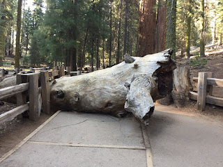
A fallen branch that shattered the concrete on impact was also handy for scale though I assumed it was a tree until I saw where it broke off the main trunk.
The Johnson family climbing among the roots of a downed sequoia. 
I appreciated the narrow winding roads and stone bridges in the park. It helped the road fit better in the woods.  


Friday, July 7, 2017

Crater Lake

Corrie and I headed south on I-5 after our sunset tour of Mt St Helens, and spent a remarkably restful night just south of Portland at the busiest rest area I have ever seen. From there we cut across Oregon to Crater Lake and spent two nights camping next to the snow because they received 48' of snow last winter.
The top of a mountain is an odd place for the deepest (1943 ft) lake in the United States, but a caldera filled with rain and snow melt makes a pretty amazing lake. Water is now evaporating and seeping out through the sides at the same rate as it collects so the surface level is relatively stable.
Snow blocked the trail about two thrirds of the way up Garfield peak.
These flowers reminded me of crocuses in Alaska except they are white instead of purple.  
Mt Shasta from above the visitor center on the rim.
Corrie taking pictures from the rim.
Wizard Island on our second morning while the lake was still.
Wait there's an Air Crane flying over the lake?
We stopped to watch the park service fly this boat down to the lake. There are no roads into the crater, so this is the only way to get a boat down there. One of the rangers told us it's been 10 years since they last flew a boat down. The video below requires flash. 


The east rim drive was still closed to cars, but Corrie and I hiked the five miles around to the trail down to the lake edge.
Another view from the North rim.
Road closed for snow... One advantage of the closed road is that we mostly had the trail to ourselves.
The view from the lake edge. The water was almost as cold as it was clear, but we went for a swim anyway. 
Corrie cooking dinner back on the south side 
Mt Shasta from the south east as we drove around it on the way to visit the Wassons.